EAST KOLKATA WETLANDS
Overview
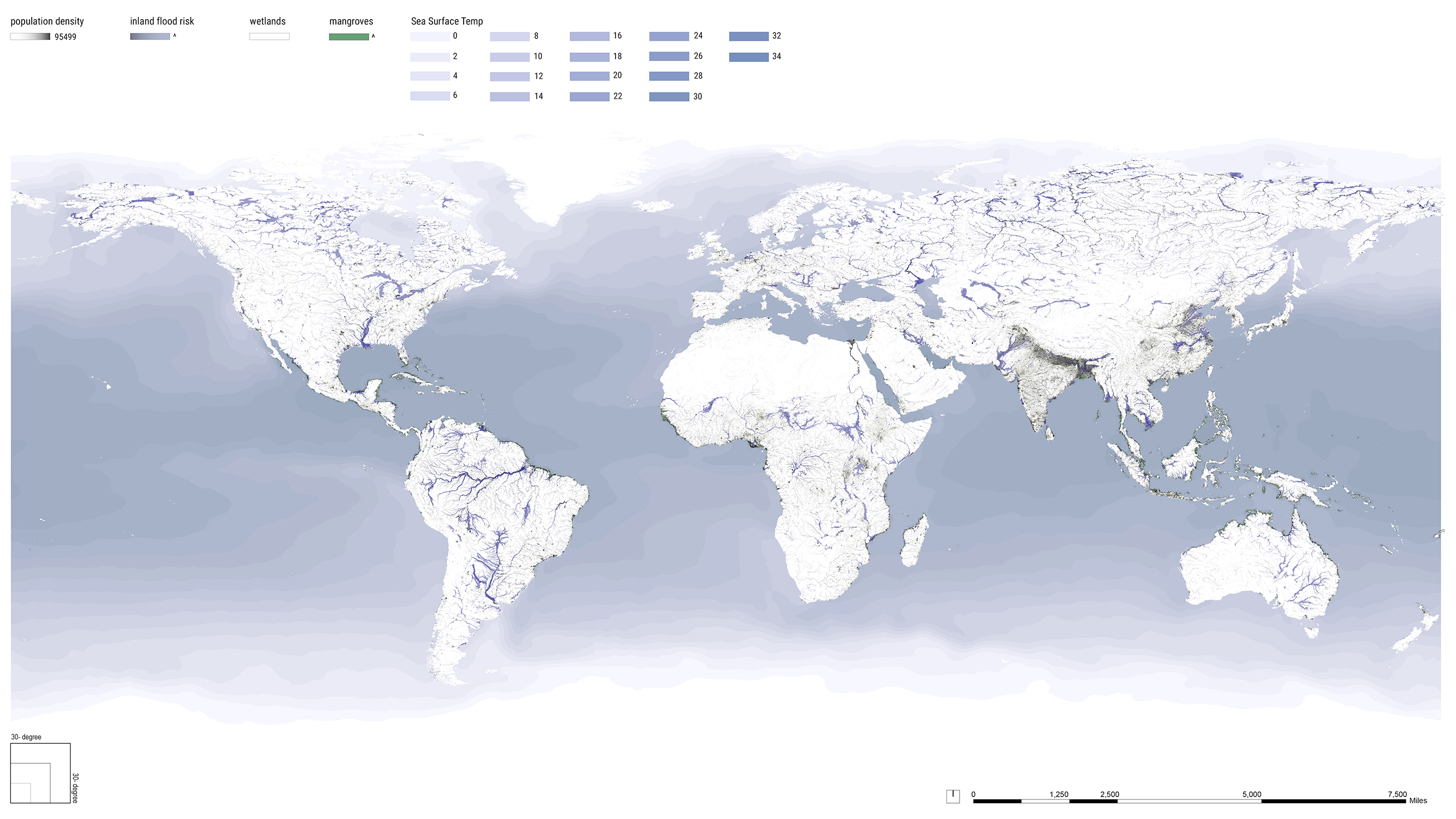
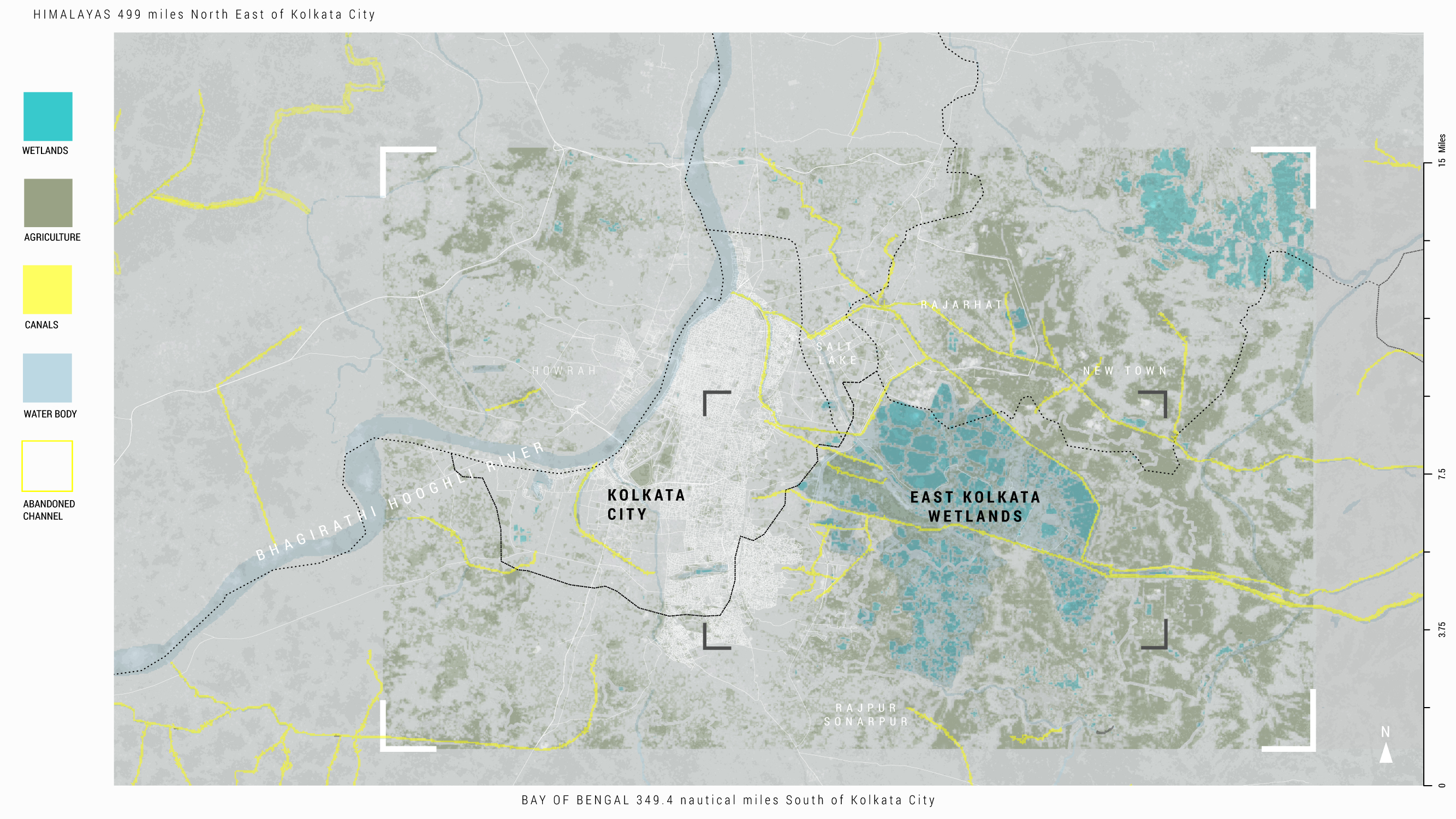
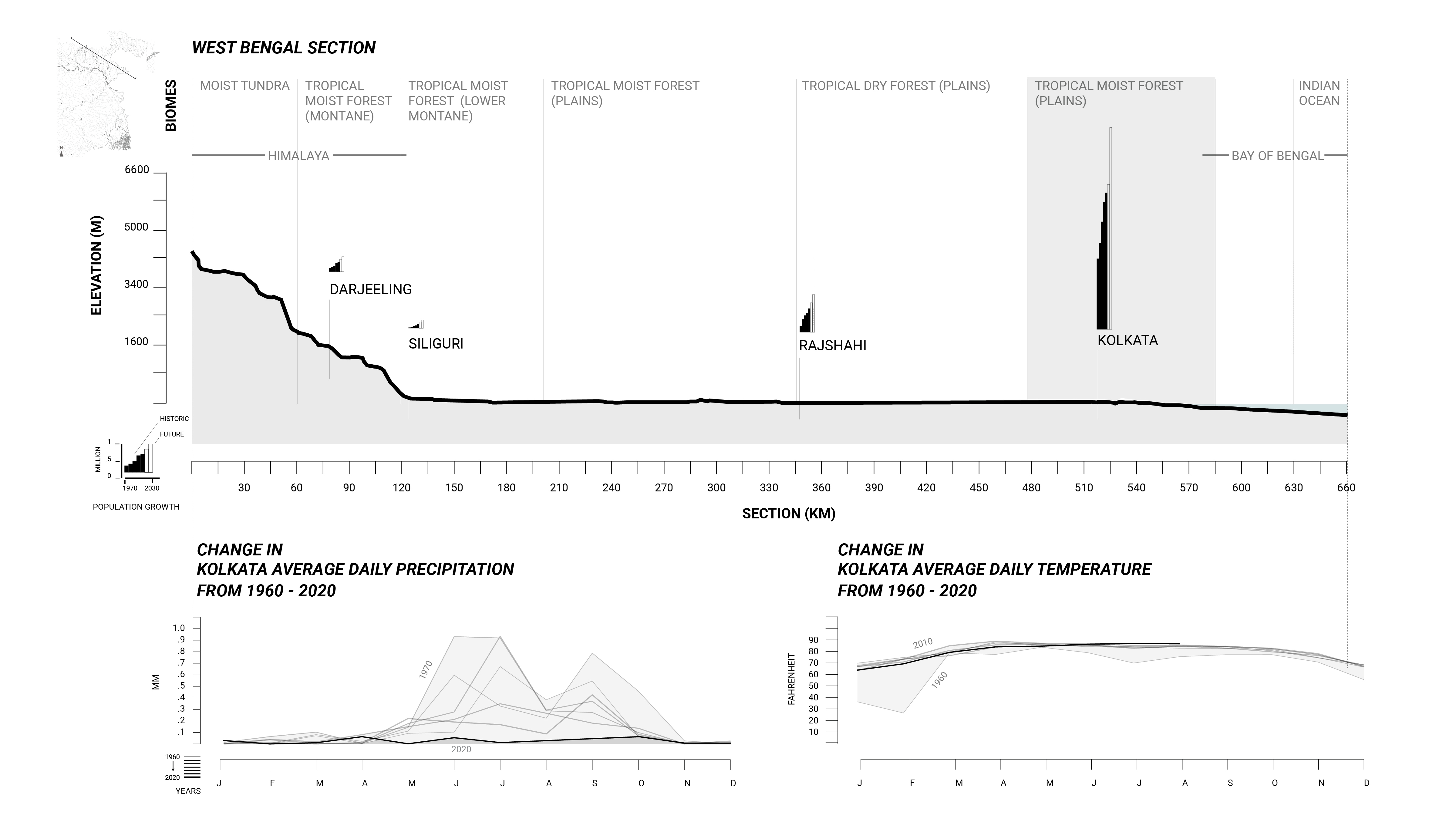
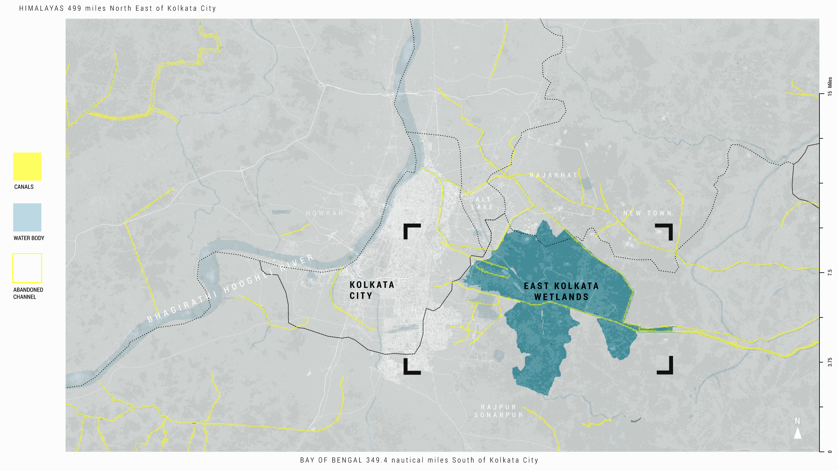
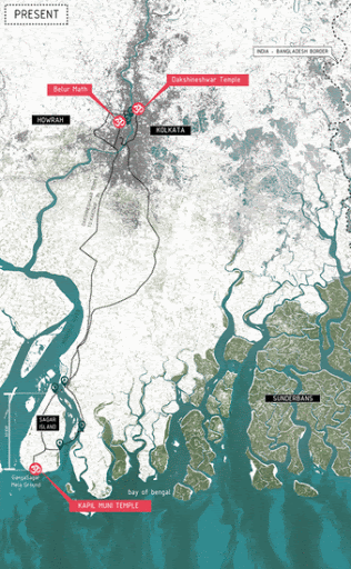
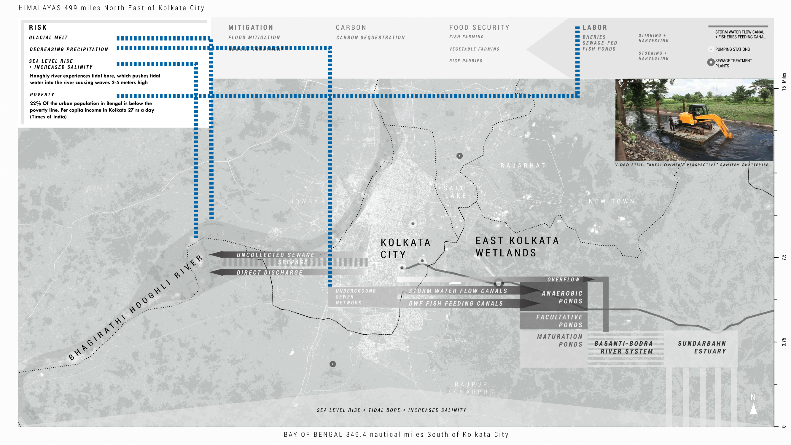
The city of Kolkata, India sits on the Hooghli River, a major distributary of the Ganges, near where the river empties into the Bay of Bengal. According to the World Wildlife Fund, the projected effects of climate change on Kolkata—and eastern Kolkata in particular—make it one of the most vulnerable population centers in Asia. Increased flooding poses the primary threat, with flooding of the Hooghli already a daily reality during monsoon season (The World Bank, 2010). Rapid urbanization has compounded this issue, making the city hotter and less permeable by replacing open space with impervious construction. This has been accompanied by an influx of new climate migrants living in informal settlements on available open space at the city’s periphery who have been displaced from their homes along the Bay of Bengal due to increased flooding from storms and sea level rise (Sengupta, 2018).
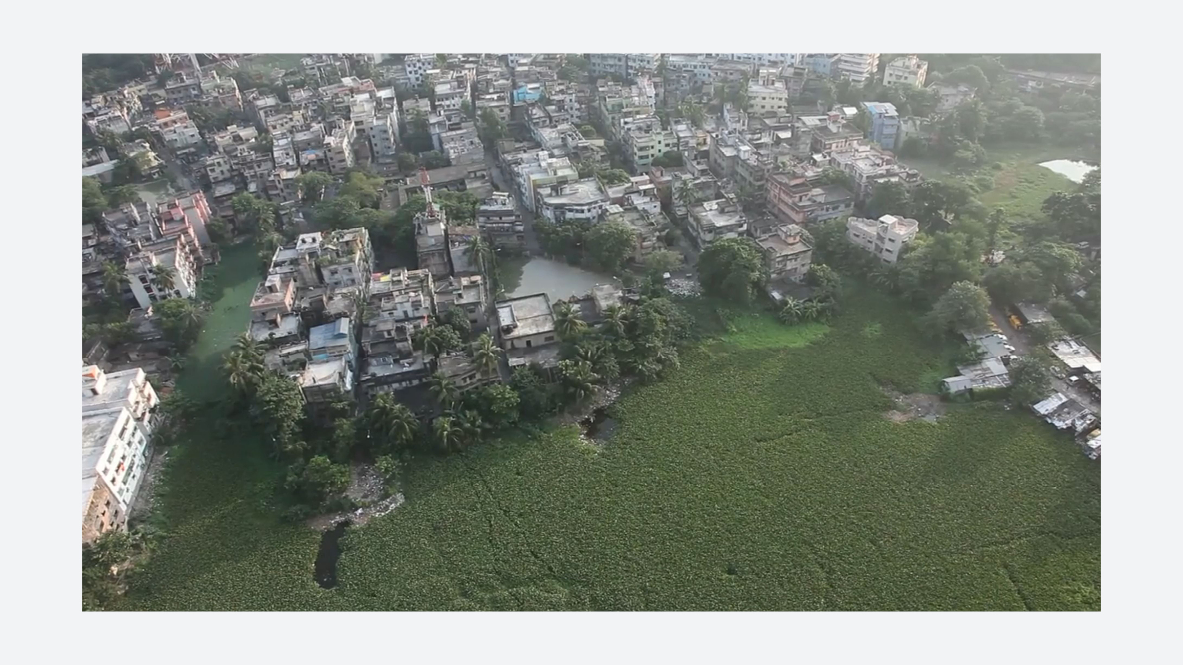
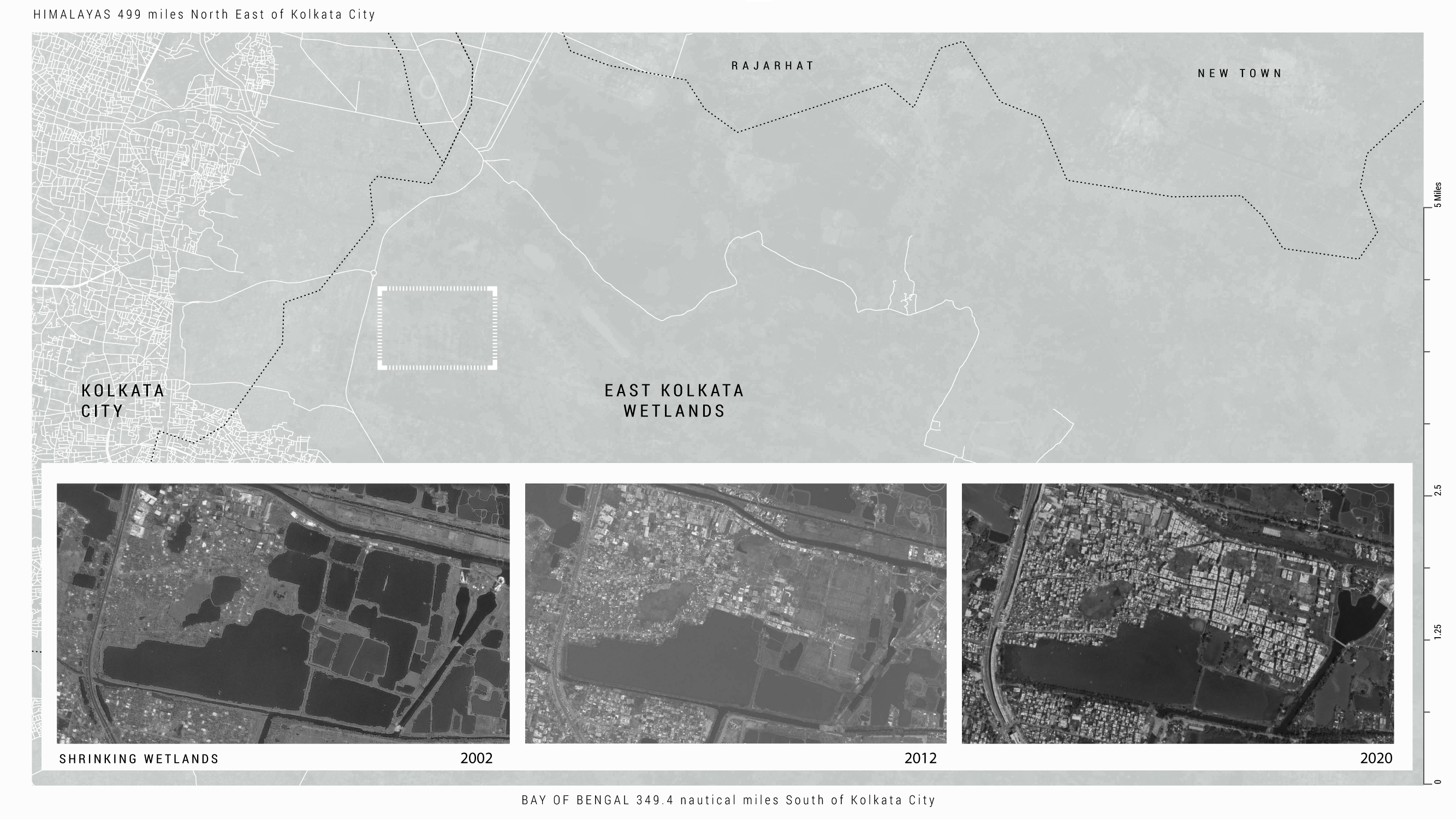
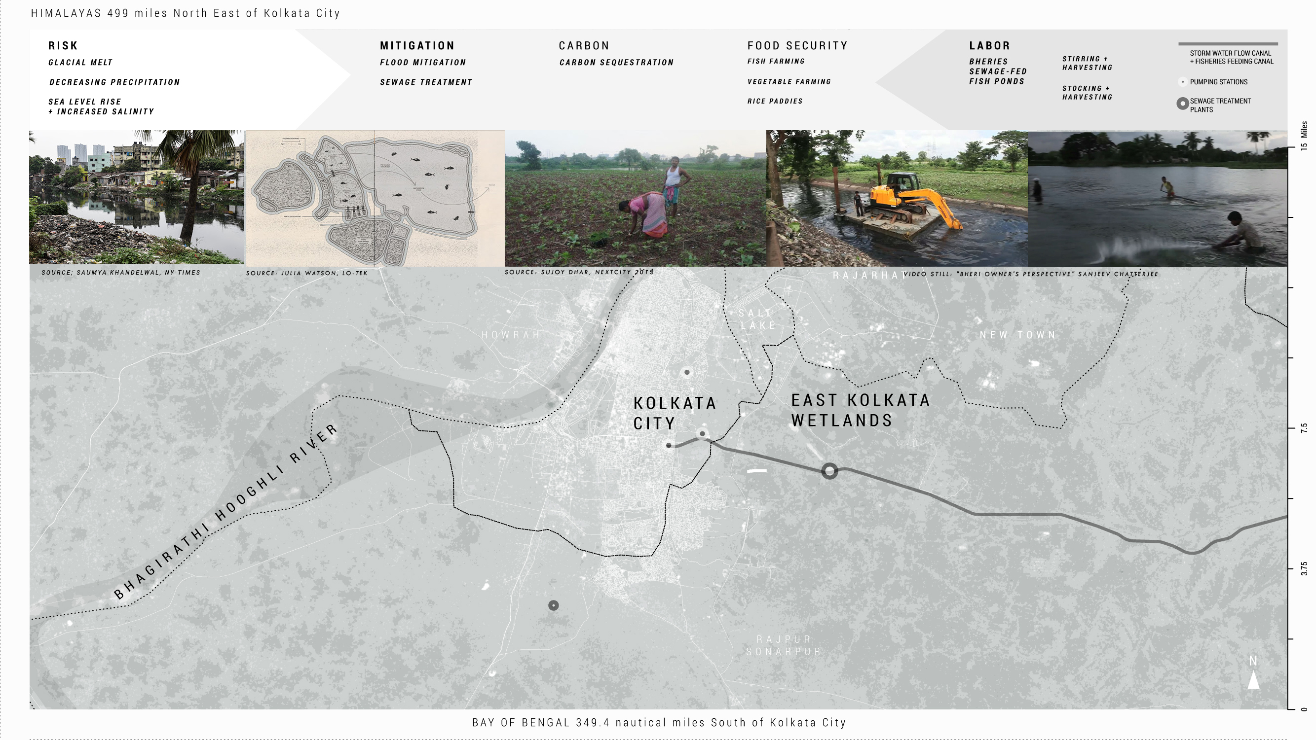
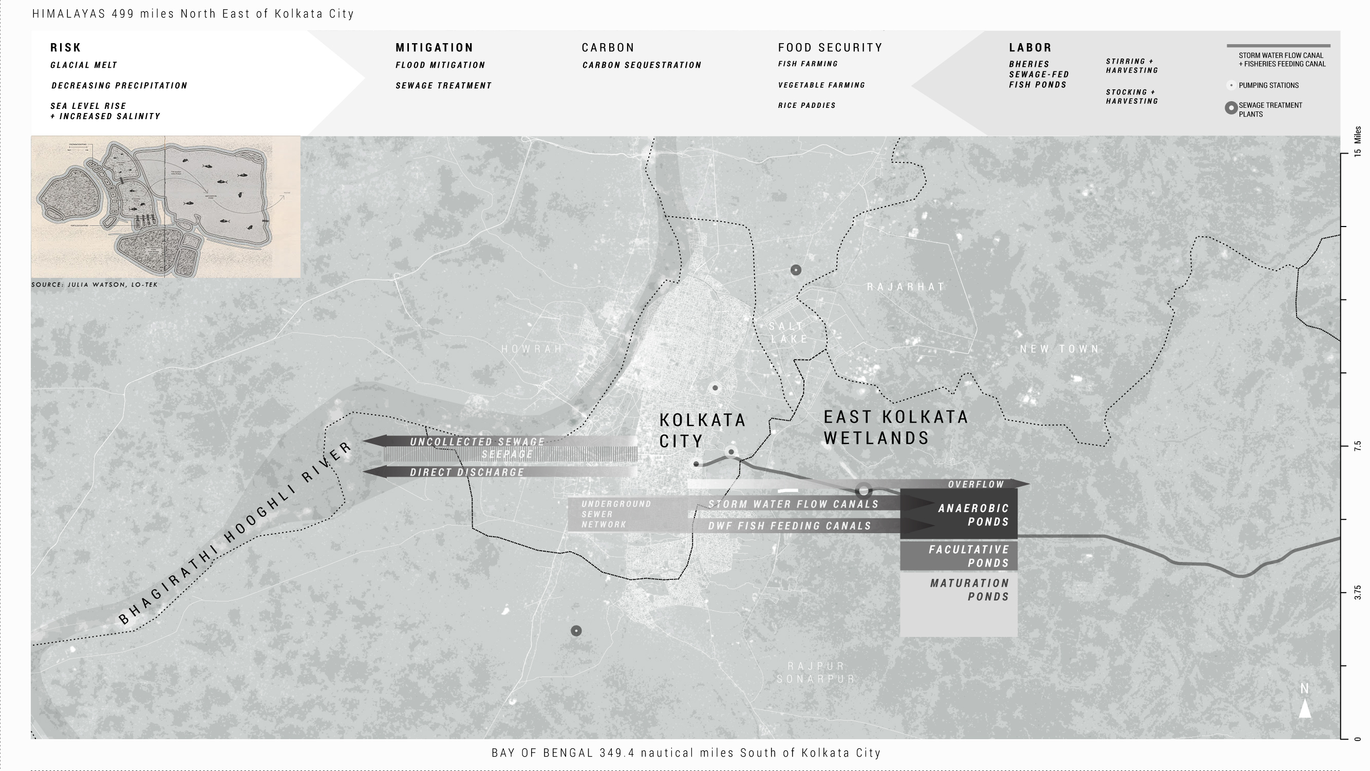
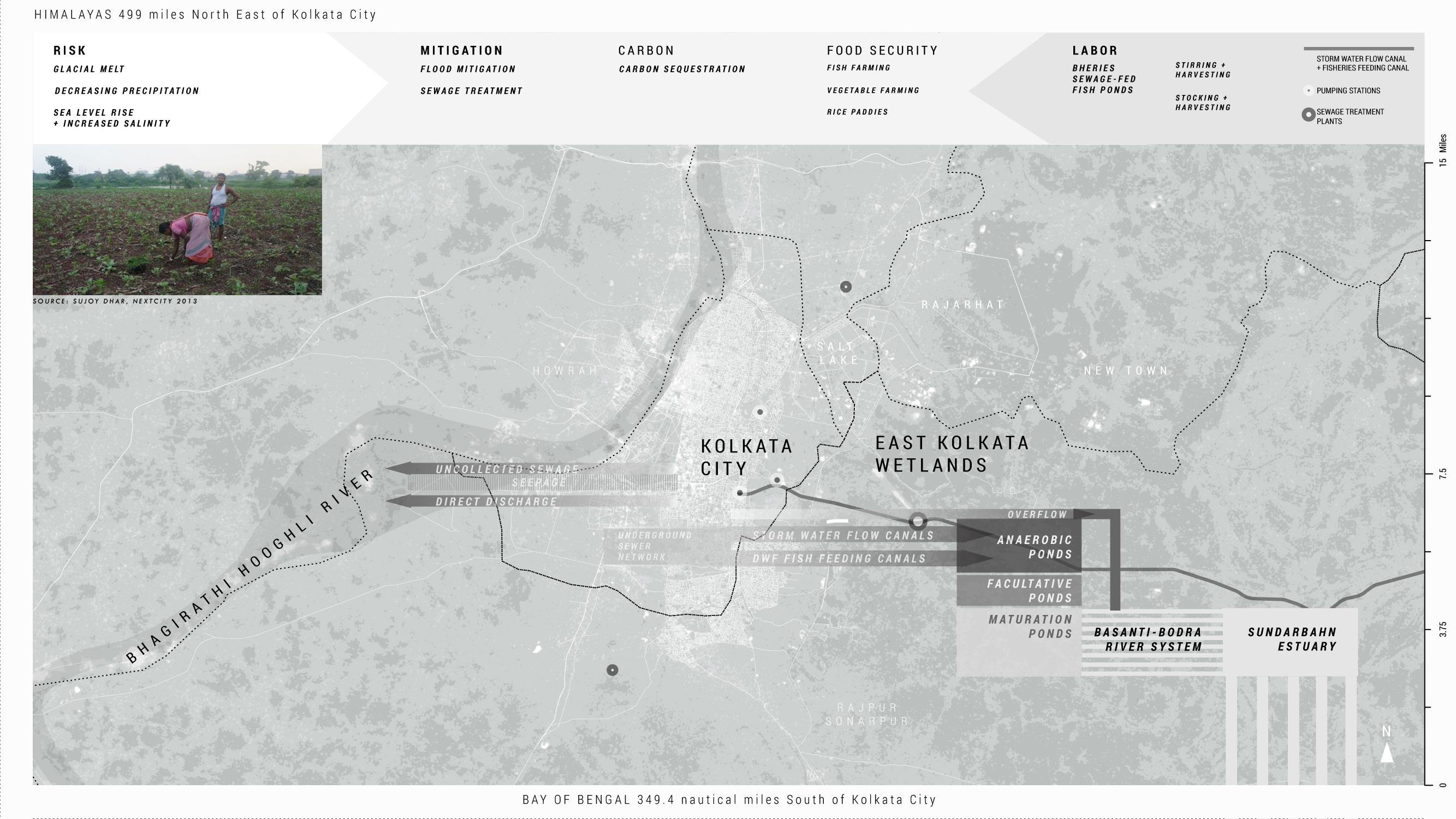
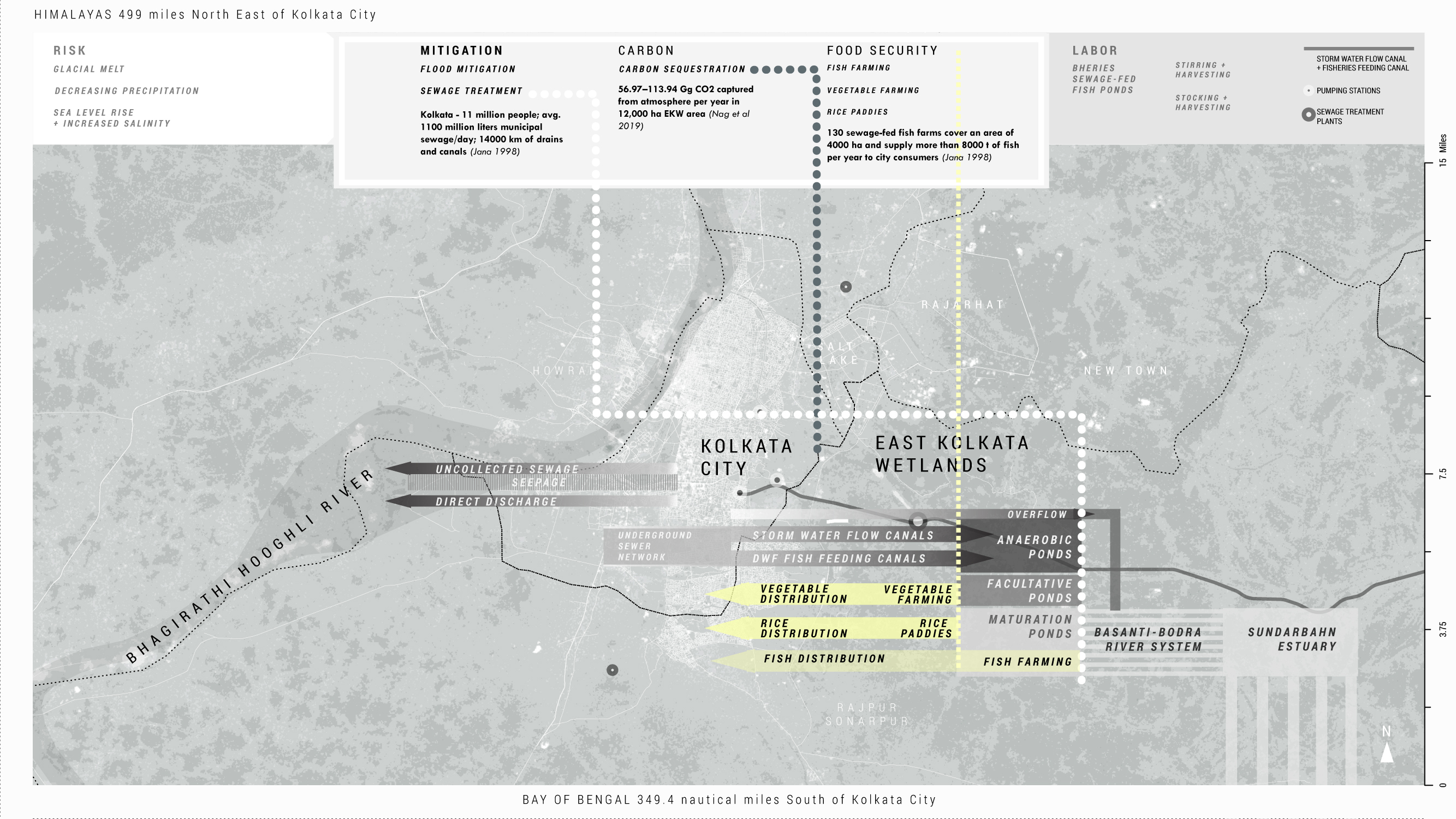
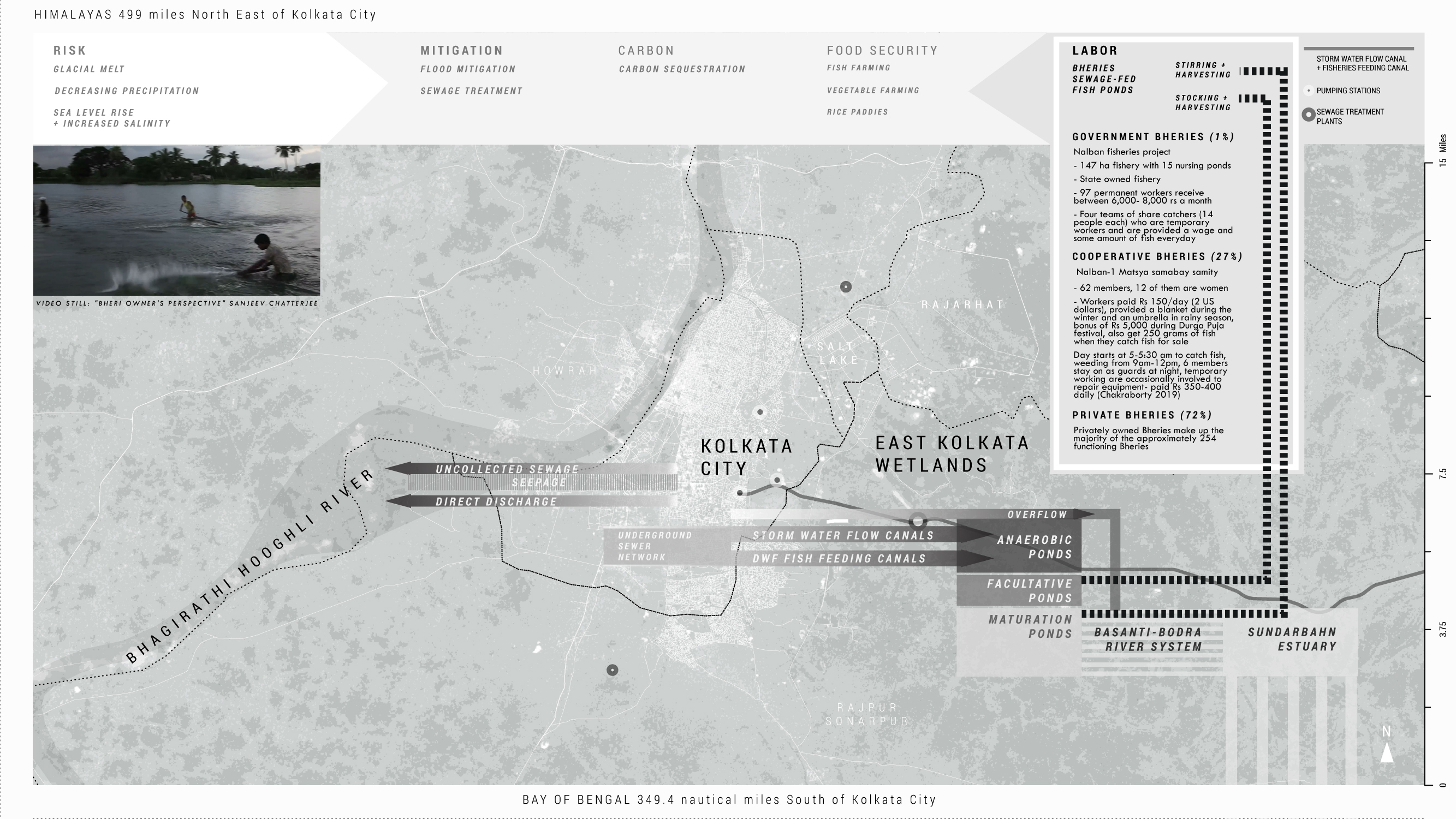
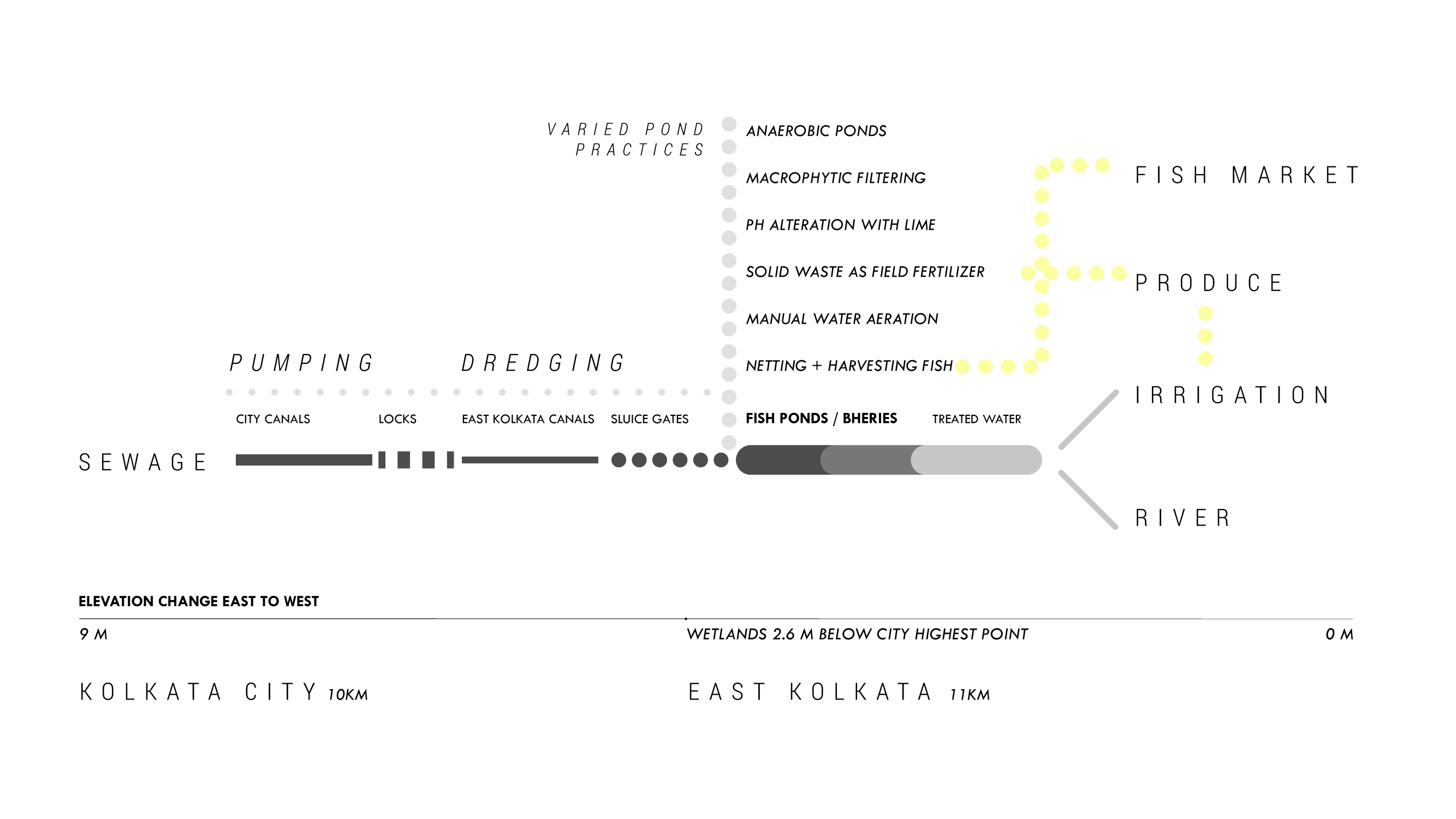
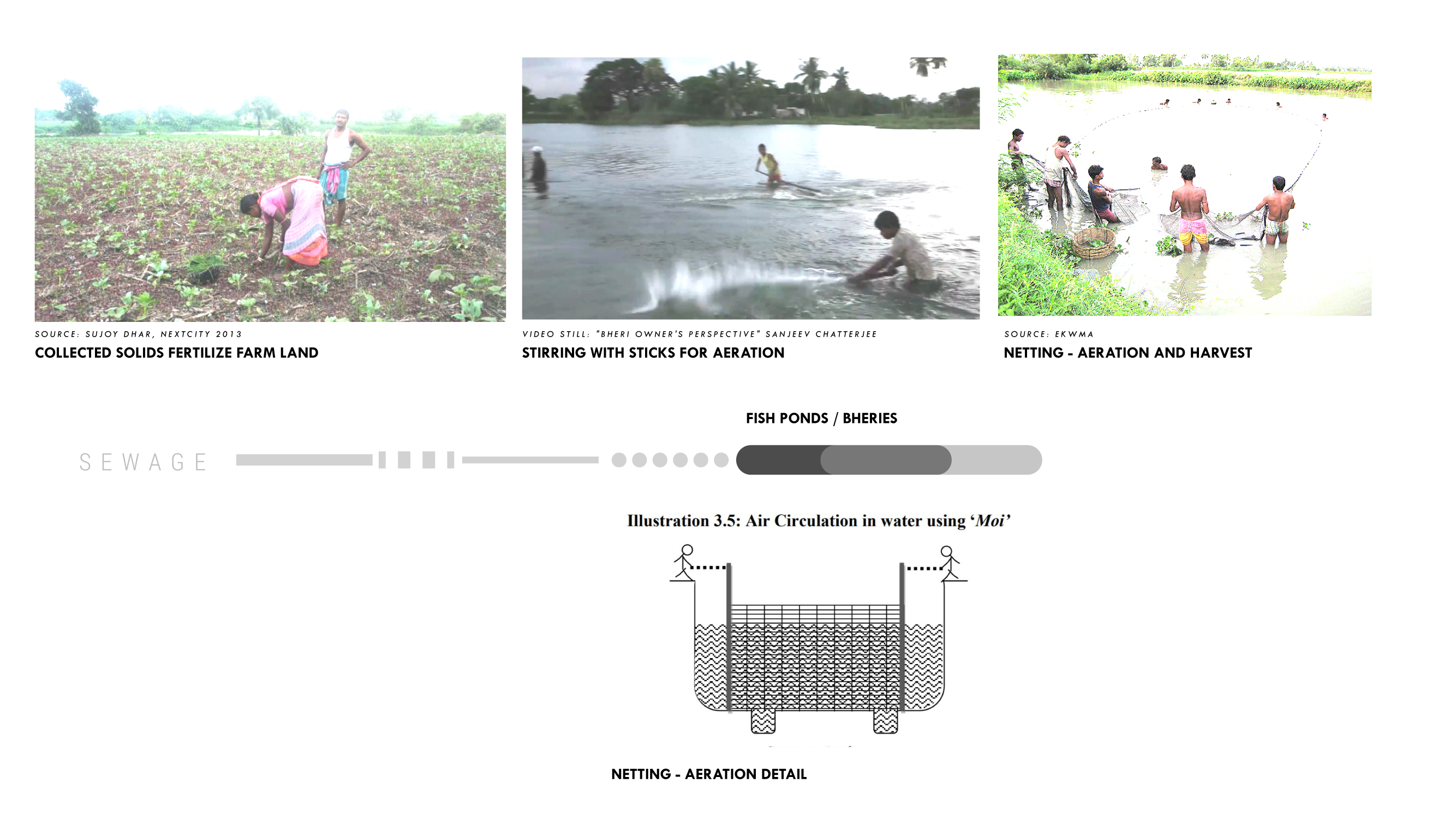
Covering more than 240 hectares, the East Kolkata Wetlands are the world’s largest landscape-based sewage system, a collection of approximately three hundred man-made fish ponds, with additional agricultural plots, fed and fertilized by wastewater diverted from the city by a series of canals (New Agriculturist). Using flora, fauna, sunlight, and gravity, instead of the more-energy-intensive technologies seen in mechanical wastewater treatment facilities, the Wetlands filter toxins from human waste, remediate the watershed, and create aquaculture and farming opportunities in the region. This, in turn, sinks approximately 180Gg CO2 each year while reducing soil nitrogen fixation and thus the need for chemical fertilizers. The Wetlands also act as an absorption buffer for the city to mitigate flooding caused by increased runoff from Himalayan ice melt upland and from storm surges in the Bay of Bengal. The ponds, which have been constructed from the remains of a drying wetland over the past century, are independently owned and operated while sharing access to the municipal canals. They were first identified formally as a single entity by the ecologist Dhrubajyoti Ghosh, a vocal champion of the fisheries who gave them the collective name “East Kolkata Wetlands” as a part of his advocacy efforts to preserve them in the face of competing urban land development pressures.
While not disputing the ponds’ capacity for climate change mitigation, some who have studied the East Kolkata Wetlands have cautioned against exporting the model to other parts of the world, especially to the West, without making region-specific amendments. Ghosh has noted that the Wetlands’ ability to provide food, jobs, and free sanitation depends upon two conditions: sunlight and poverty. The former condition transforms waste into nutrient-rich fish food, the latter condition creates the imperative for the intense, unpleasant, and underpaid labor required to operate the fish ponds while maintaining their thin profit margins (Jadavpur University, 2011). There are also regulatory structures in many parts of the world that would make selling fish and crops grown with sewage legally challenging; even in Kolkata, residents who have a choice are unjustly skeptical of the quality of the fish that are raised in the Wetlands (Chakraborty and Gupta, 2019).
Organizations & Governance
East Kolkata Wetland Management Authority (EKWMA)
Union Ministry of Environment and Forestry (India)
Ministry of Environment (Government of West Bengal)
Kolkata Municipal Corporation
Irrigation Department of West Bengal
Ramsar Convention Bureau
Institute of Environmental Studies and Wetland Management, Government of West Bengal
Dhrubajyoti Ghosh, Former Chief of the Department of Environment, Government of West Bengal
LEGISLATION / REGULATION / DECISIONS
People United for Better Living in Calcutta v. State of W.B. (PUBLIC)
The East Kolkata Wetlands (Conservation and Management) (Amendment) Act, 2017
EKW (C&M) ACT 2006
EKW (C&M) Rules 2006
National Environment Policy 2006
EKW (C&M) (Amendment) Act, 2008
Wetlands (Conservation & Management) Rules 2017, MoEF&CC, GOI
EKW (C&M) (Amendment) Act, 2011
Key Terms
INTRO


Kolkata
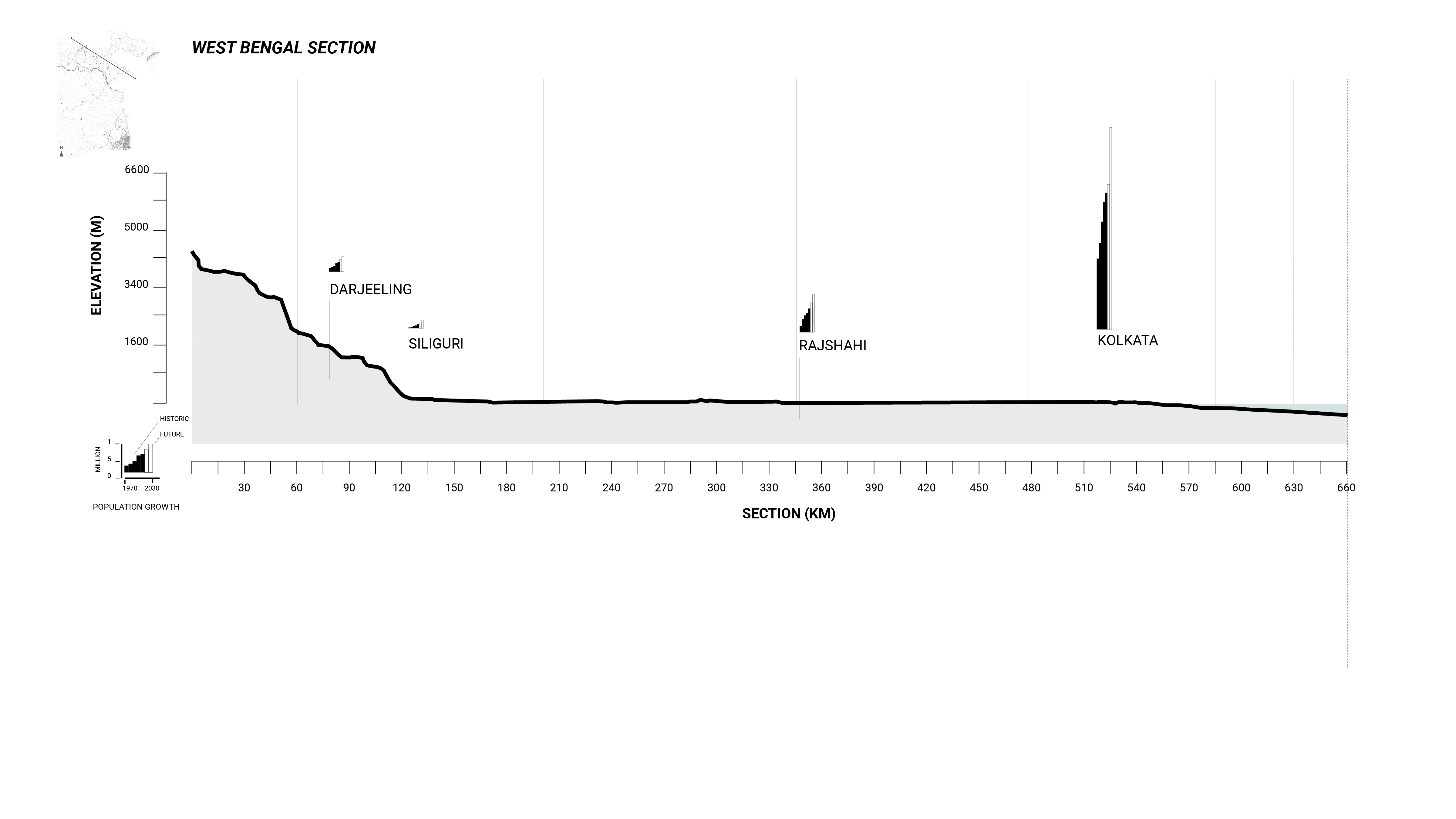
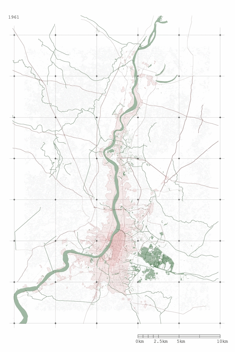
With waters rising in the northern Bay of Bengal at nearly twice the rate of most of the world (a positive trend of 6.26 ± 1.29 mm per year) and a rate of land subsidence as high as 13.78 mm per year, the city of Kolkata is extremely vulnerable to climate change-related flooding. This threat is compounded by the city’s expanding urbanization, concentration of poverty, the loss of farmland and food security, as well as open spaces that might otherwise absorb rainfall. The East Kolkata Wetlands attempt to address many of these issues, while illustrating a climate mitigation project tailored to a specific landscape and labor conditions.
CLIMATE CONDITION


SHRINKING WETLANDS


![Fig 15. Another graphic from Columbia’s GSAPP “Water Urbanism Kolkata” studio shows the existing and projected wetland property loss in the East Kolkata Wetlands: Shrinking Wetlands: Impact of Ecological Loss, RE[DE]FINING MONUMENTALITY From Colonial Resistance to Ecological Justice, Chris Chiou, Grace Ng, Mario Ulloa, Kristen Reardon.](https://freight.cargo.site/t/original/i/41e6a50d61b8123ea199f2efba34fee8bf8955dc8cde7b99fdb9585ef40aa306/EKW-Gallery03_07_5-Change-Map-GIF.gif)
COMPOUNDING RISK

WORKERS, FISHERS, FARMERS


CONFLICTING BOUNDARIES
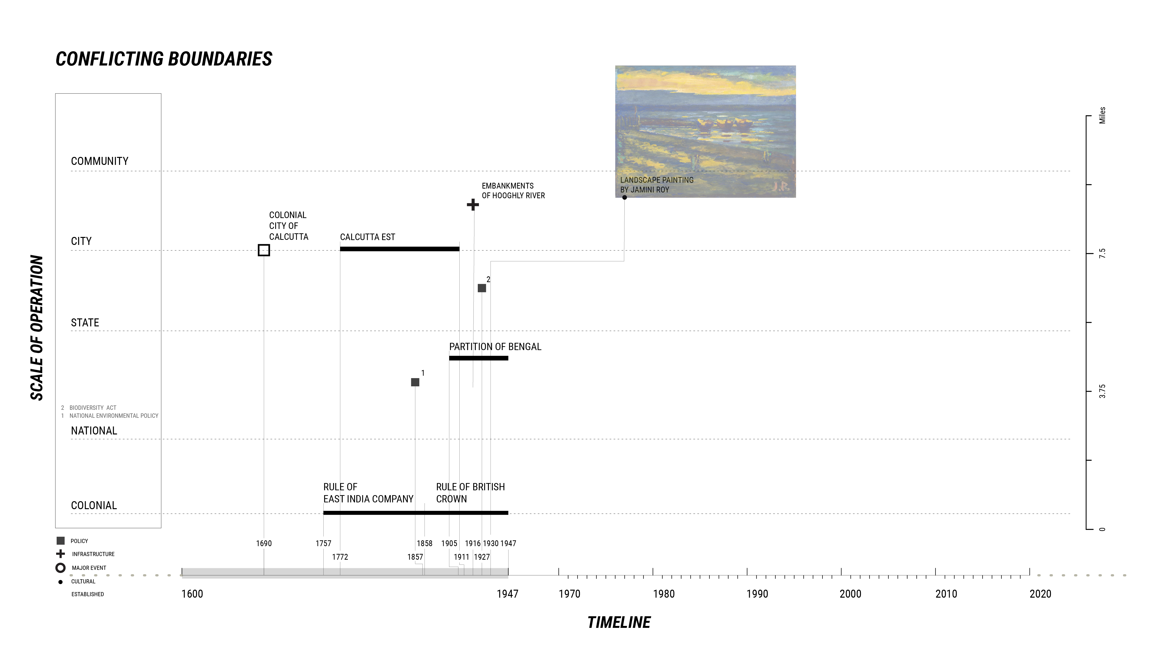

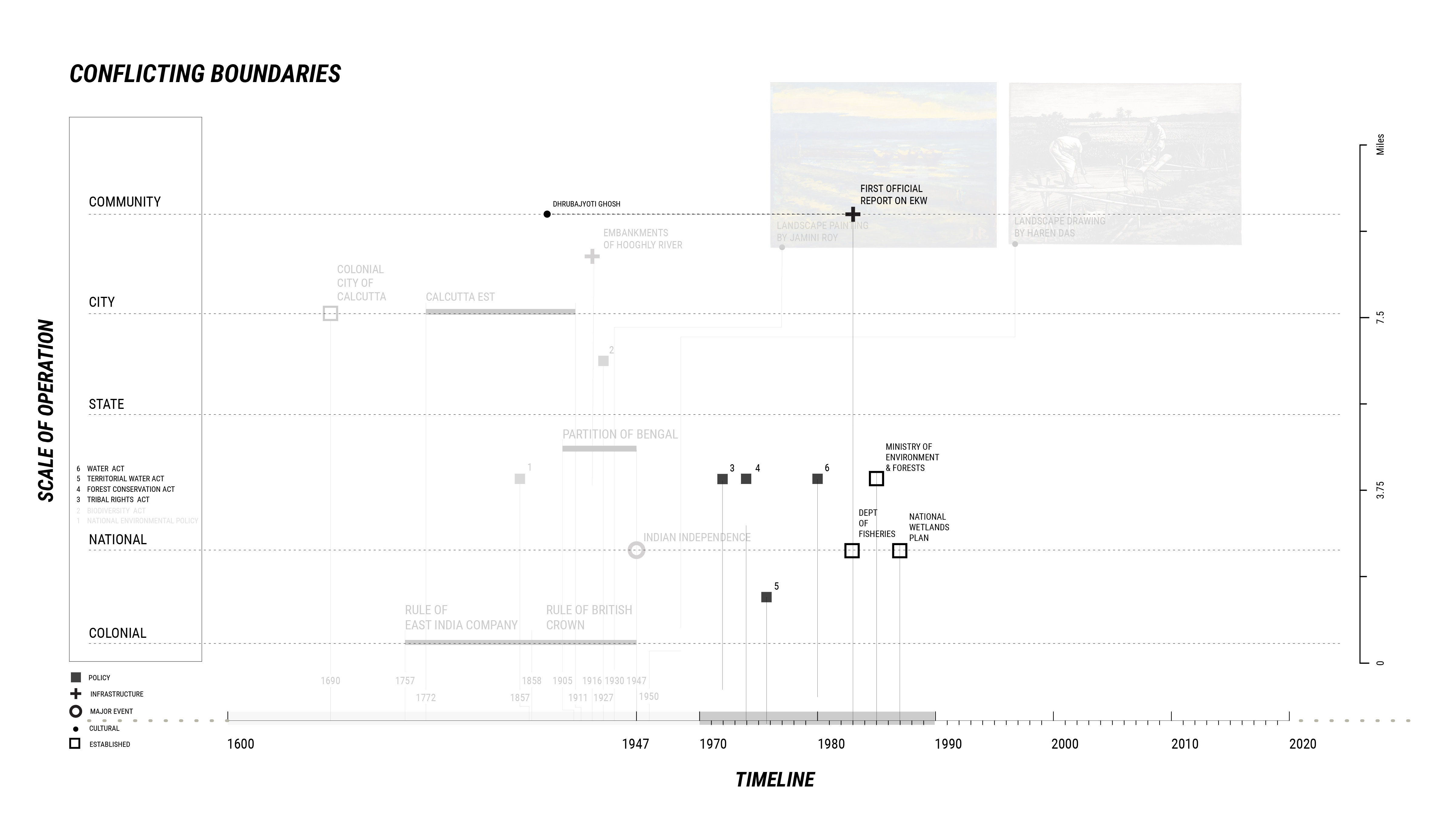
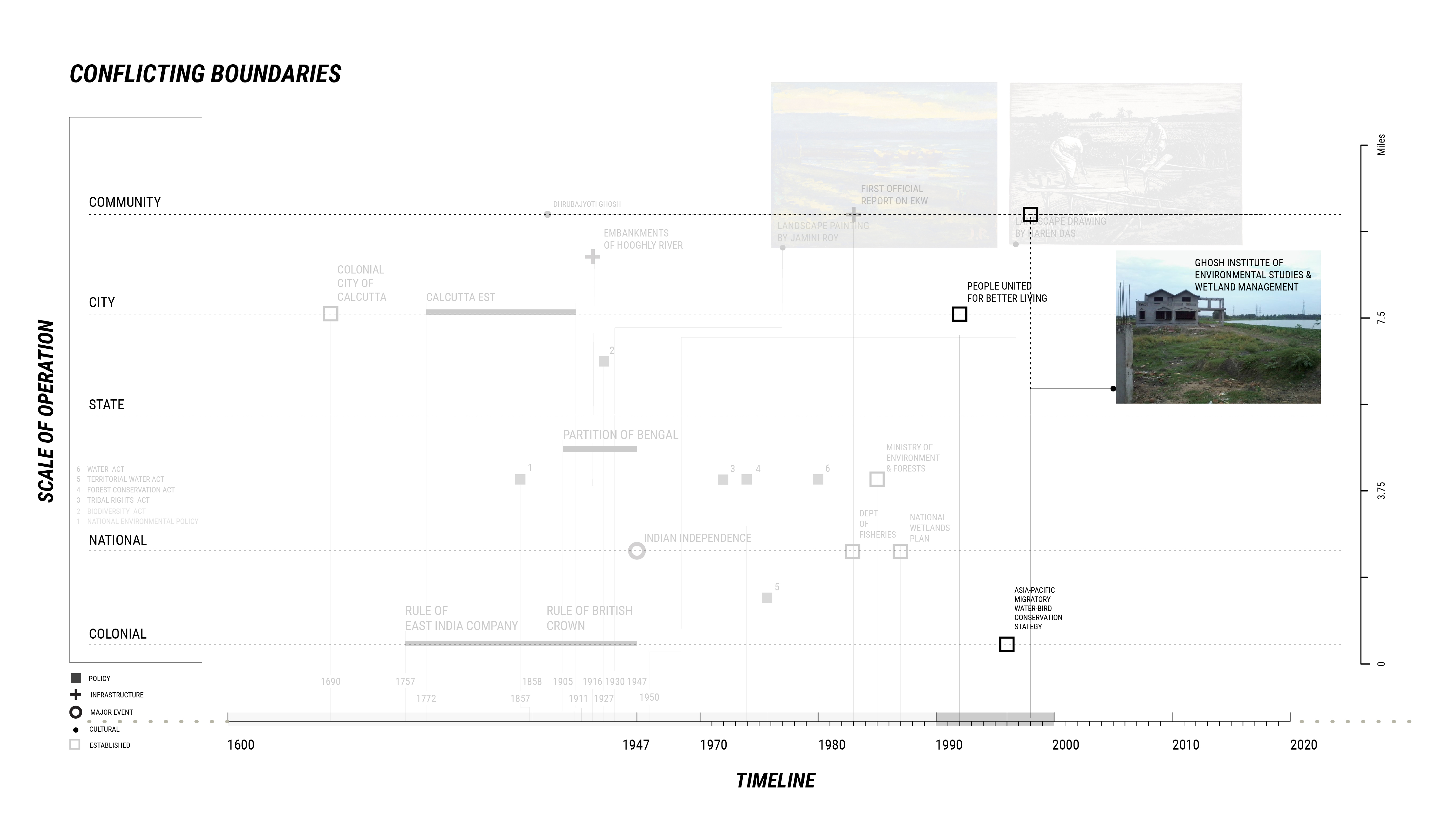

Despite being protected by its international status as a wetland of importance under the Ramsar Convention, the East Kolkata Wetlands lack the integrated management, municipal ownership, and oversight necessary to maintain environmental quality and prevent illegal commercial and residential development from encroaching on the area. With no known governmental plans to change this, the Wetlands will continue to shrink and the Kolkata metropolitan area will face major difficulties processing its waste, producing food, and providing employment to those now working and living in the wetland areas.
SOURCES
Bunting, Stuart, Jules Pretty, and Peter Edwards. “Wastewater-fed aquaculture in the East Kolkata Wetlands, India: Anachronism or archetype for resilient ecocultures?” Reviews in Aquaculture 2 (September 2010), 138-153.
Carlisle, Stephanie. "Productive Filtration: Living System Infrastructure in Calcutta," Scenario Journal, Spring 2013, https://scenariojournal.com/article/productive-filtration/.
Chakraborty, Gorkhy and Dhruba Das Gupta. “Protecting the Kidneys of Kolkata – the East Kolkata Wetlands.” India Water Portal (8 August 2019). https://www.indiawaterportal.org/articles/protecting-kidneys-kolkata-east-kolkata-wetlands.
Dhara, Chirag. “West Bengal’s climate change conundrum Part II: Changing rainfall patterns have left Kolkata vulnerable to flooding; here's why.” Firstpost, February 20, 2019. https://www.firstpost.com/india/west-bengals-climate-change-conundrum-part-ii-changing-rainfall-patterns-have-left-kolkata-vulnerable-to-flooding-heres-why-6112851.html.
Doshi, Vidhi. “Kolkata: The City that Eats Fish Reared on Sewage.” The Guardian. 25 January 2017. https://www.theguardian.com/sustainable-business/2017/jan/25/kolkata-west-bengal-india-cites-fish-farming-sewage-food-demand-real-estate.
Gangopadhyay, Anasua, and Parthajit Patra. “The Historical Background of the Canal System in Calcutta, India, and Its Contribution to Development.” Proceedings of the Institution of Civil Engineering - Engineering History and Heritage 173, 3 (August 2020), 80-91. https://doi.org/10.1680/jenhh.19.00024
Ghosh, Krishna Gopal. “Analysis of Rainfall Trends and its Spatial Patterns During the Last Century over the Gangetic West Bengal, Eastern India.” Journal of Geovisualization and Spatial Analysis 2, 15 (2018). https://doi.org/10.1007/s41651-018-0022-x.
Ghosh, S., S. Hazra, S. Nandy, P. P. Mondal, T. Watham, and S. P. S. Kushwaha. “Trends of Sea Level in the Bay of Bengal Using Altimetry and Other Complementary Techniques.” Journal of Spatial Science 63, 1 (2018): 49-62. DOI: 10.1080/14498596.2017.1348309.
Guhathakurta, Pulak, Shirish Khedikar, Preetha Menon, Ashwini Kumar Prasad, S. T. Sable, and S. C. Advani. “Observed Rainfall Variability and Changes over West Bengal State.” Government of India, Ministry of Earth Sciences, India Meteorological Department, Pune, January 2020.
Hettiarachchi, Missaka, Clive McAlpine, and T. H. Morrison. “Governing the Urban Wetlands: a Multiple Case-Study of Policy, Institutions and Reference Points.” Environmental Conservation 41, no. 3 (2014): 276–89.
Jadavpur University. “Give Me Poverty and Sunlight and I Will Give You Free Sanitation.” September 16, 2011. Vimeo video, 2:00. https://vimeo.com/29156933.
Jana, B. B. “Sewage-fed Aquaculture: The Calcutta Model.” Ecological Engineering 11 (1998): 73-85.
New Agriculturist. “East Kolkata Wetlands.” http://www.new-ag.info/02-4/focuson/focuson5.html.
People United for Better Living in Calcutta Public and Another v. State of West Bengal and Others, Matter No. 2851 (Calcutta High Court 1992). https://www.casemine.com/judgement/in/56095fafe4b01497112caeaa.
Sahu, Paulami, and P. K. Sikdar. “Threat of land subsidence in and around Kolkata City and East Kolkata Wetlands, West Bengal, India.” Journal of Earth System Science 120, no. 3 (May 2011): 435-46.
Sengupta, Somini. “The City of My Birth in India Is Becoming a Climate Casualty. It Didn’t Have to Be.” New York Times (New York, NY), July 31, 2018. https://www.nytimes.com/2018/07/31/climate/the-city-of-my-birth-in-india-is-becoming-a-climate-casualty-it-didnt-have-to-be.html.
Watson, Julia. “Bheri Wastewater Aquaculture of the Bengalese, India.” In Lo-TEK: Design by Radical Indigenism, 322-39. Cologne: Taschen, 2019.
World Wildlife Fund. Mega-Stress for Mega-Cities: A Climate Vulnerability Ranking of Major Coastal Cities in Asia. World Wildlife Fund, January 2009. https://www.alnap.org/help-library/mega-stress-for-mega-cities-a-climate-vulnerability-ranking-of-major-coastal-cities-in.
The World Bank. Climate Risks and Adaptation in Asian Coastal Megacities: A Synthesis Report. 2010. http://indiaenvironmentportal.org.in/files/Climate%20Risks%20and%20asia.pdf.