*INFORM @RISK | Primary Case
Medellín, Colombia
German Federal Ministry of Education and Research, Christian Werthmann
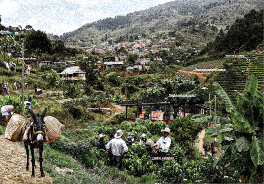
Medellín, Colombia is built in the Aburrá valley around the Medellín River, and is organized into 271 barrios, or neighborhoods, with a dense city center spreading out up the mountains bordering the valley in the urban periphery. During periods of heavy rainfall, the peripheral hills are subject to significant landslides due to the instability of the volcanic soils upon which the neighborhoods are built. The neighborhoods on the hillsides are often informal settlements, with a moderate quality of housing construction, but poor municipal services and construction. While the risk of landslides is increasing due to greater rainfall, the toll of landslides is exacerbated by uncontrolled urbanization, poor social development, a loss of native vegetative cover and engineering and construction failures that have deteriorated the natural hydrology across the valley. The cost of relocating outstrips the means of many of these communities, and the Inform @ Risk project was created to find ways for the neighborhoods to remain despite the increasing threat of landslides. The Inform @ Risk project was initiated to look at three scales, the city of Medellín, a nested district scale, and a further nested neighborhood scale. Through monthly community meetings with members of the German and Colombian research teams. Three different approaches to intervention were evaluated as strategies: a mitigation strategy focusing on current and existing neighborhoods, a second group of strategies for future occupation and a final group of strategies for the resettlement of people in the most dangerous sites. Five pilot projects have been identified, a project to localize measurement of landslide risk factors and sound alarms to evacuate residents, improving drainage through soil to avoid saturation, micro-farming on steep slopes, reestablishing protective forests, and finally identifying land for future growth. The project highlights the ability of landscape architects to act as mediators between the community and specialists, and to use their generalist expertise to work through a project from regional siting to specific design details.
2019 - 2022
50 acres
4905 feet above sea level
50 acres
4905 feet above sea level
tags: soil stabilization, protect, mobility, agroforestry, urban farming, afforestation, resilience, hazard reduction, risk reduction, remain, community, institutional, scenario plan, training program, design project, evacuation plan, communication, erosion, flooding, landslide, deforestation, pollution, environmental justice, displacement, poverty, densification, inequity, post-conflict, landscape metrics, South America, Neotropical, Tropical Rainforest
References:
|
Finn, Megan. “Making Sense of Earthquakes: Public Information Infrastructures and Postdisaster Event Epistemologies.” Documenting Aftermath: Information Infrastructures in the Wake of Disasters. Cambridge: MIT Press, 2018: 1-18. Werthmann, Christian. “Inform @ Risk.” Research Gate Project Page. Accessed July 6, 2020. https://www.researchgate.net/project/InformRisk Werthmann, Christian. "Inform @ Risk: Improving the resilience of informal urbanization against landslides through participative networks of early warning systems, web based technologies and landscape design." 2019. https://www.bmbf-client.de/sites/default/files/2019-06/2019-05-09%20Medellin%20Inform%40risk.pdf Claghorn, Joseph and Christian Werthmann. "Shifting ground: Landslide risk mitigation through community-based landscape interventions." Journal of Landscape Architecture 10, no. 1 (2015): 6-15. Claghorn, Joseph, Francesco Maria Orsini, Carlos Alejandro Echeverri Restrepo, Christian Werthmann. "Rehabitar la Montaña: strategies and processes for sustainable communities in the mountainous periphery of Medellín." Brazilian Journal of Urban Management (2015). https://www.scielo.br/pdf/urbe/2015nahead/2175-3369-urbe-2175-3369008001SE03.pdf. |